
Make new discoveries using digital maps.
Have you ever wondered what was there before your home was built? What kinds of rocks lie beneath your feet? The National Library of Scotland has developed a special viewer that allows you to compare a wide range of old and new maps side by side.
Explore the National Library of Scotland’s amazing Side by Side Map Viewer here
How to use the viewer
First, a help page will appear which you can either read or close down. For the simplest version of the viewer, we suggest you click on Go to former Side by Side viewer in the green box top right of the screen.
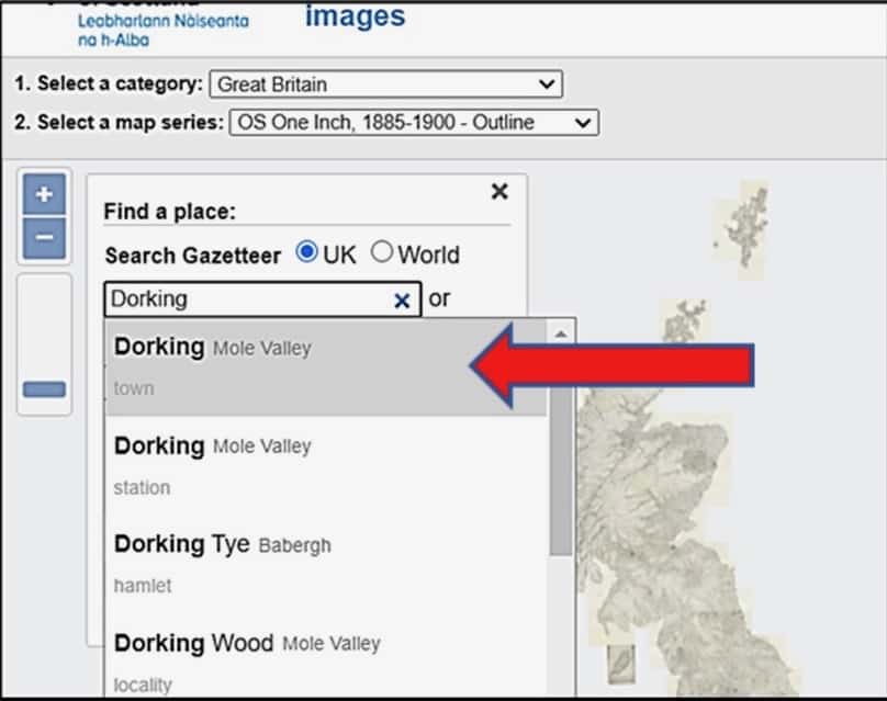
To make a start, click on the Search Panel. In the box marked Search Gazetteer, type Dorking.
A dropdown list will open. Click on Dorking, Mole Valley.
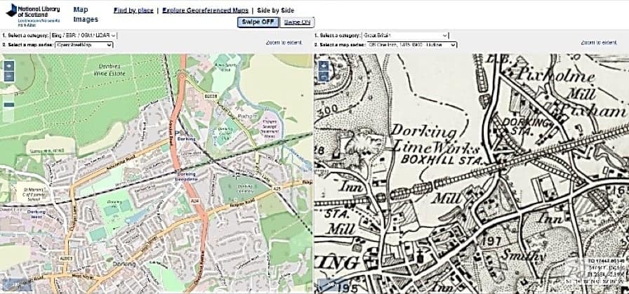
The cursor in the right-hand map corresponds exactly with the same place on the left-hand map.
You can zoom in or out to find your home or school on today’s map, then see what the same place looked like on earlier maps.
Try putting OpenStreetMap in the left frame, then put the 1900s OS 1:1 million – 1:10K map in the right-hand frame.
Things to look for
What was there before your home or school was built?
Explore the area to discover which places have been lost and which features still remain between modern roads and buildings. How has Dorking changed over a hundred years?
A new type of map, called LiDAR, has been added to the map viewer and people are now using it to make new discoveries in the landscape.
What is LiDAR?
LiDAR is short for Laser imaging Detection and Ranging and uses lasers on satellites and aircraft to map the landscape in 3D. LiDAR reveals the precise up and downs of the landscape, which is extremely useful to archaeologists and historians. It is a fantastic new tool to investigate the past.
Clues, such as ditches and traces of old buildings are often difficult to see from ground level because of trees and vegetation.
For example, take a look at the two maps below to see what LiDAR reveals. The satellite map on the left shows the riverside walk just under the white cliffs of Box Hill at Burford Meadow. This is next to the A24 dual carriageway. The LiDAR image on the right sees through the trees to reveal… a cluster of sink holes!
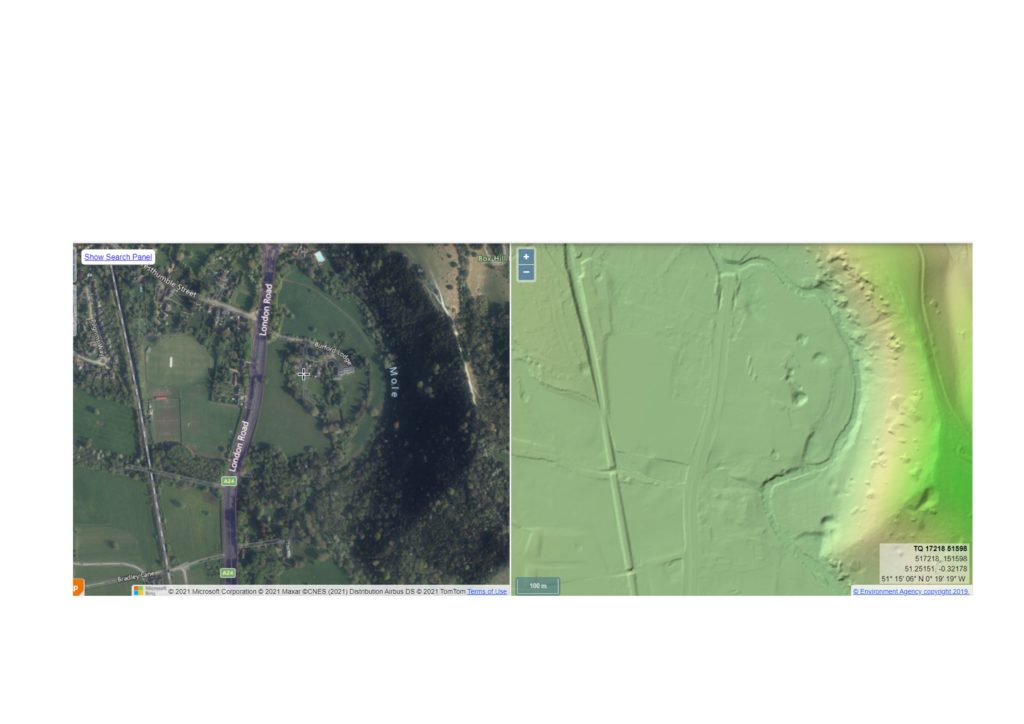
LiDAR just sees what it sees, so it doesn’t distinguish between new features (such as modern buildings and roads) and features that have been there for hundreds or even thousands of years. That’s where field investigation comes in – there is no substitute for seeing a place for yourself.
Investigate Burford Meadow yourself by taking a walk along the riverside path, which is close to Ryka’s Café and the Burford Bridge roundabout. Can you find the sink holes?
A River Mole mystery recently solved using LiDAR
This incredible engraving in Dorking Museum’s archives shows the whole of the River Mole vanishing down a curious ‘swallow hole’ into the underworld in 1840. Such an event almost defies the imagination! Yet, a reliable eyewitness account, recorded in Brayley’s Topographical History of Surrey, described the scene:
‘In one instance, the current was altogether lost within a few yards beyond the Wooden Bridge which stands about half a mile below Burford Bridge: here its last rill trickled into a crevice under the western bank of the river.’
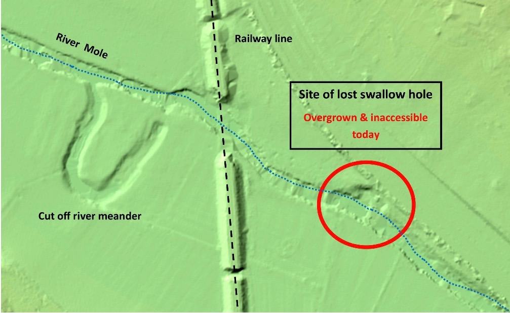
But where did this strange phenomenon happen? There is no trace of it on today’s maps or satellite images.

The swallow hole that caused the 1840 vanishing was thought to have been filled in many years ago and lost forever. However, LiDAR image reveals that the cavity is still there because it left its mark in the landscape. Whether the swallow hole has become active again remains a mystery.
Weird holes on Ranmore
This cluster of holes was spotted on the LiDAR map of the Polesden Lacy nature reserve on Ranmore. It can be found by going to the search panel of the Side by Side Map Viewer and entering the National Grid Reference: TQ13152 50818. Here you can compare the LiDAR map with a range of other maps of the same place.
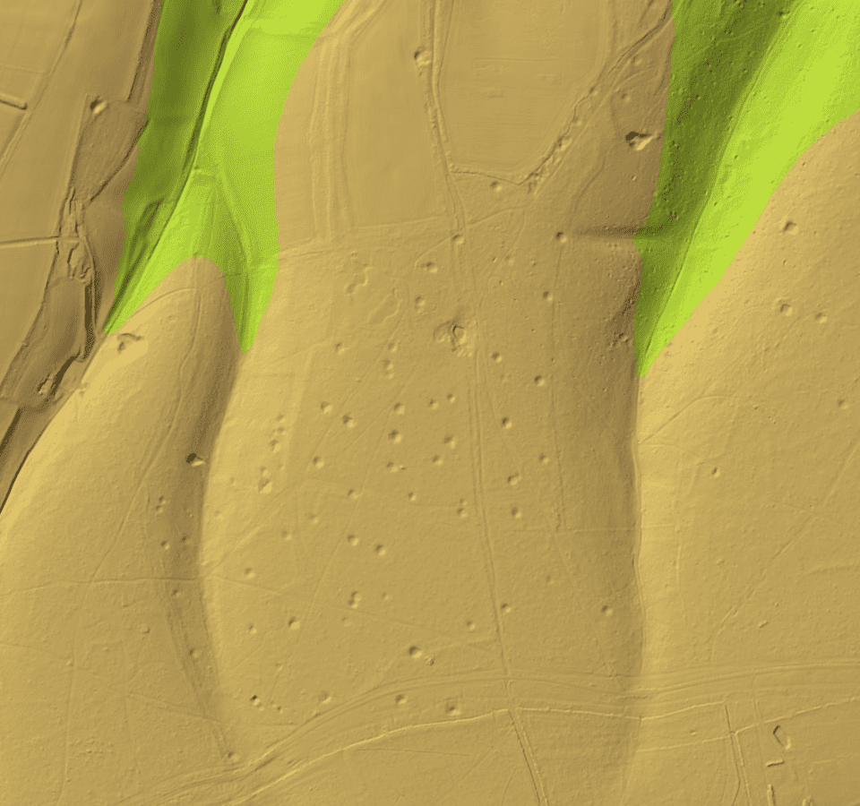
What do you make of these strange holes? Could they be sink holes, craters made by exploding wartime bombs or something else? We know Canadian troops were active in the area during the Second World War. Does this give us any clues? For the moment, these holes remain a complete mystery.
See if you can make any new discoveries using the LiDAR maps.
Images with courtesy:
National Library of Scotland
Crown copyright
Environment Agency

