Discover more about the bombs that hit Dorking in the Second World War
In the early days of the Second World War, Dorking suffered ‘hit & run’ air raids on its railways and roads, along with many other areas of S.E. England.
For most of the war Dorking was not a main target, though its position on the flightpath between the London and Germany’s airfields made it particularly vulnerable from the air. German bombers, escaping back to their bases after air raids on the capital, flew over Dorking and the surrounding area.
German bombers were ordered to dump their leftover bombs wherever they could do the most damage so they could lose weight to quickly gain height and make a getaway. Whenever they could spot them, bomb aimers picked out targets such as railway lines and buildings. Some country houses had been taken over as wartime headquarters and Allied troops were also stationed in the area.
Warplanes from both sides duelled in the skies above Dorking – several aircraft were shot down and crashed in the surrounding countryside.
By the end of the war, 121 air crashes had been recorded within just 10 miles radius of Dorking. Some planes crashed because they were damaged or ran out of fuel. Others tragically misjudged their height over steep hills during poor visibility. Victims and survivors include crews from Germany, the United States and the Royal Air Force (with fliers from Poland, Canada, New Zealand and others).
Towards the end of the Second World War, a new menace came in the form of flying bombs (doodlebugs). Their guidance systems were not accurate enough to hit specific targets. Instead, they were aimed in the general direction of London and used as weapons of terror. Many fell short.
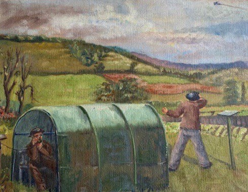
Photo courtesy of Reg Rose
This painting by A.S. Brewer depicts spotters from the Royal Observer Corps reporting a flying bomb over Milton Court.
Read the stories behind some of Dorking’s most serious wartime incidents.
See the map in full detail by visiting the museum where you can take a closer look.
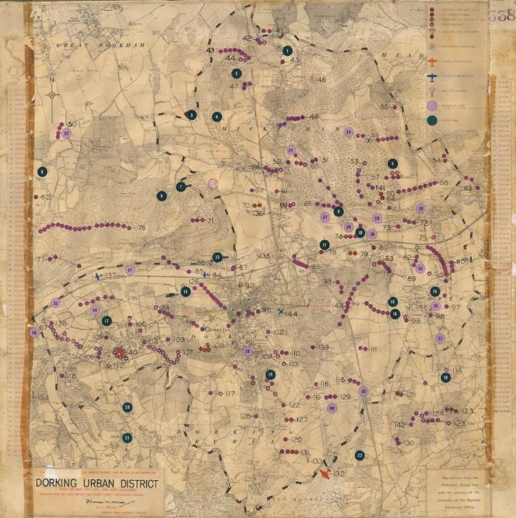
The more detailed Dorking Urban District Council incident map (shown below) records everything that happened between 1940 and 1945. Bomb incidents, air crashes and parachute escapes were carefully recorded as they happened by the civil defence staff & the police.
This map now hangs on the wall at Dorking Museum and is one of the museum’s most precious documents.
To understand why these records served such an important purpose during the war, you need to put yourself into the minds of the authorities who were desperate to understand what might happen next. The records could be searched for clues such as patterns and trends to help build up a picture of what the Germans were trying to achieve at any one time.
For instance, how much did the Germans know about what was going on around the Dorking area? Did they know about the secret spy training camp on Box Hill (at Villa Bellasis) or the wartime railway headquarters hidden in a complex of tunnels beneath Deepdene House? What kinds of features did they select as targets?
It is important to remember that many of the bombs falling around Dorking were not targeted at anything. They were simply dumped by the terrified German aircrews who just wanted to gain height and get away before they were shot down.
These were desperate times for people on both sides of the conflict.
Things to look out for on the incident map when you visit the museum
Each symbol and coloured dot (or line of dots) marks the location of a single event. The key at the top right of the map explains what all the symbols mean. There are symbols for air crashes (Allied and German), great parachute escapes and different types of bombs.
The dates of each numbered incident are listed down the sides of the map.
Find out what happened near your home or school?
Bombs
We might think that ‘bombs were bombs’, but many different types of bombs were developed for different purposes. The authorities were anxious to know what types of bombs were being used and, most important, if new types of weapons were being tried out:
- Incendiary (fire) bombs set fire to buildings and forests. Once alight, wind would make the fire spread. Find where incendiary bombs were dropped?
- High explosive bombs caused huge shockwaves that could destroy buildings, bridges and railways. Railways were particularly important targets because trains were used to transport guns, troops and supplies. Where were the high explosive bombs dropped?
- Parachute bombs were explosive mines, similar to the floating mines used to sink ships at sea, except that they were dropped from aircraft by parachute. When they were detonated at roof-level they could destroy everything within 100 metres radius. Only one parachute bomb landed in our area – see if you can spot where it exploded. What do you make of this incident? Was it aimed at a particular target or was it just a heavy leftover they needed to hastily get out of the aircraft?
- Photographic flash bombs were exploded in mid-air to light up the ground at night so airborne cameras could take spy photographs of suspicious places. The aerial photos were used by the German air force to plan future raids. However, it is quite possible that some flash bombs were dropped simply because the aircraft navigators were lost. Even a fleeting glimpse of a church spire or a cliff lit up for a few moments could save their lives. Where did the flash bombs go off? Are there any clues to suggest that they were looking for something in particular?
- Flying bombs were new a new type of weapon that first fell from the skies towards the end of the war. They were ‘pulse-jet’ or rocket-propelled missiles. Unlike today’s cruise missiles, their guidance systems were crude, so they were simply aimed in the general direction of London. The ones that fell short (because they ran out of fuel) struck at random in the Dorking area – sometimes with terrible consequences. 30 flying bomb impacts were recorded in our district alone.
The map shows that many of the bombs did not explode when they hit the ground, so a particularly important function of each observation was to mark the positions of unexploded bombs so they could be made safe by bomb disposal experts or destroyed without further loss of life.
You will see, for instance, that a cluster of unexploded bombs in Westcott coincides with the crash of a German Dornier bomber in Parsonage Lane on 24th February 1944. Perhaps the bombs failed to explode because the charges had not been set as the pilot tried to save the aircraft and crew.
When we look at the map today, the Dorking Urban District Council incident map reveals the true scale of the devastation in our area and is a lasting reminder of what the people of Dorking had to endure throughout the Second World War.