Dorking’s Roman highway
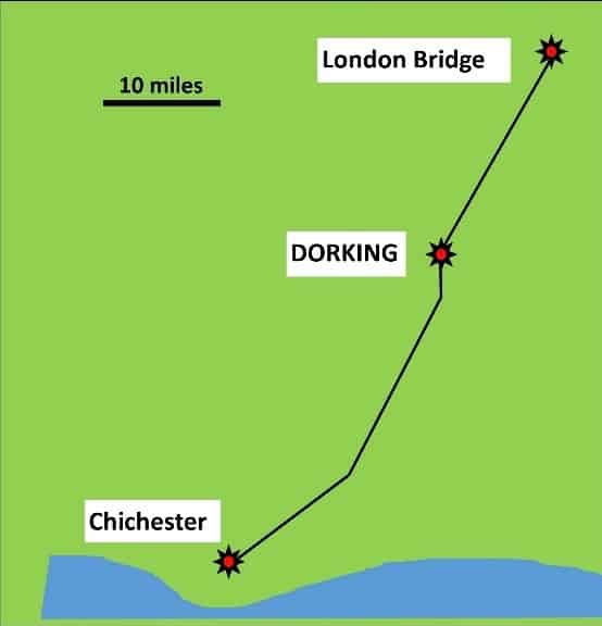
Stane Street (which means Stoney Street), linked the Roman seaport at Chichester (on the south coast) to the centre of London. Stretching 56 miles from end to end, it was the motorway of its day. By Roman standards, it was a wide road, built between ditches 7 metres (24 feet) apart.
Roman roads were straight, but the Romans built them in straight sections that could deviate from the exact line from London to Chichester. The Romans wanted the most direct route through our area without too many obstacles and diversions, but the road-builders were allowed to adjust their route to avoid, for instance, steep cliffs or boggy areas.
They couldn’t avoid hills altogether and they had to find a way up and over the North Downs. However, they went round the steepest slopes when they could. That is because, as well as being a route for soldiers, it was also a route for horse-drawn carts carrying goods and supplies, which are not very good at going up and down steep slopes.
The other obstacle was the deep, sticky clay between the Dorking area and the south coast (especially during a wet winter), with London clay to the north, so they had to find the most solid ground to build their road.
They chose their route wisely and some modern roads still follow the same route.
Where Dorking lies today, the main challenge for the Romans was to find a way between (or across) the sandstone hills that make up our town.
The Stane Street Mystery
Nobody knows the exact route of the Roman highway through Dorking because hardly any evidence has been found. It doesn’t help that their road-building materials (mainly flint and sand) were probably robbed at a later date to reuse as building materials for walls and homes.
Some think the Roman highway must have run along South Street and then followed the route of the High Street towards a crossing point on the River Mole. Others say it might have gone straight over Pump Corner and the High Street towards Ashcombe School and beyond. Or did it go over right over the Glory Wood and Cotmandene?
They wanted a direct route, but there may be other unknown reasons why the Romans chose their exact route, such finding water from springs or to join up existing settlements at the time – who knows?
It all remains a mystery and is hotly disputed by experts.
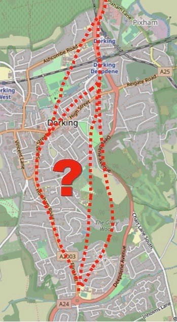
Here’s what we know so far:
- A section of Roman road was found at the foot of Box Hill close to the Zig Zag road. To the north of Dorking, Stane Street took a sideways route upwards and over the North Downs towards London.
- There is also evidence of a Roman-made ford, used to cross the River Mole where Burford Bridge lies today. This is near Westhumble – again, to the north of Dorking.
- There is good evidence of Stane Street at North Holmwood, to the south of Dorking.
Evidence we are not so sure about:
- A piece of Roman road was discovered where Horsham Road meets Dorking’s one-way system at South Street. But was it just a minor Roman side street?
- Evidence of a possible flint road was found during construction of a building in Church Street close to St Martin’s Church in the centre of town. Again, this could be just a side street.
- There is thought to be a Roman well under St Martin’s Church, but was it anywhere near the highway?
And that’s about it!
The search continues
Local archaeologist, Frank Pemberton, has spent years searching for clues on old maps and by digging test pits. He reports:
‘Despite endless test pits along Flint Hill, Horsham Road and South Street, no trace of the road has emerged. Even the excavation at the Waitrose site with its underground carpark failed to produce the road or Roman pottery and nothing has been found at the site of the newly constructed Dorking football club.’
Has everyone been looking in the wrong place? Perhaps. Frank plans to continue his quest by digging test pits to the east side of Dorking around Goodwyns and Cotmandene.
The yet-to-be discovered evidence to prove the route of Stane Street is probably buried under today’s buildings, roads and gardens.
Can digital maps help us find clues?
The Roman road surveyors were highly skilled. They knew their rocks, as well as how to make accurate measurements of the terrain using simple instruments. They had to work out their route the hard way, by going out on foot and in all weathers. Today you can do similar surveys using digital maps on the internet.
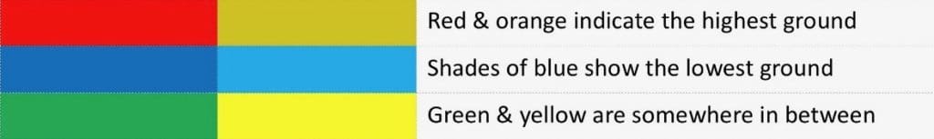
With digital maps you can, at least, make a ‘best guess’ at a suitable route. Remember, the Romans wanted the straightest route, but they also wanted an easy route. Geology maps show the layout of the rocks beneath our feet, while Topographical maps, like the one below, strip away all the buildings and show the exact height of the ground using colours.
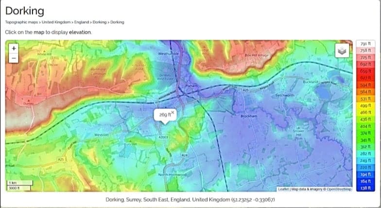
On this map, the height of each place above sea level is colour-coded to make it easier to see:
Project: Imagine you are a Roman road engineer. Where would you route Dorking’s Roman highway?
Take a look a topographical map of Dorking by clicking on the interactive map below:
Dorking topographic map, elevation, relief (topographic-map.com)
By clicking your cursor at any point on the map, you can see the exact height above sea level of the land where your cursor lies. Note, this is in feet rather than metres, though this doesn’t matter for our purposes.
You can also zoom in to see more detail, such as today’s street names.
Have a play with the topographical map, so you get to know how to use it. For instance, how high above sea level is your home or school?
Your challenge
Now imagine you have been ordered to find the easiest route for a Roman road between Westhumble, where the A24 road crosses the River Mole (in the middle at the top of the map,) and North Holmwood roundabout (in the middle at the bottom of the map). This is the missing section of Stane Street. Putting aside other considerations, such as joining up settlements, which way would you go?
Don’t forget, none of today’s roads or buildings were there when the Romans arrived. There were just a few trackways between small settlements criss-crossing the land. You are about to build the first solid stone highway across this wild stretch of land and the Roman soldiers will not be pleased if you get it wrong!
Use the online topographical map of Dorking to get started. Have a notebook handy to write your observations.
Step 1: What would be the straightest route through the missing section between Westhumble & North Holmwood?
Find out whether this would be a good route by checking the heights at several points along your straight line.
First, put the cursor at Westhumble and click to show the height, then make a note of it.
Now put the cursor at the North Holmwood roundabout to show the height there. Make a note.
You will notice that both ends of the chain are low-lying areas compared with some of the surrounding hills.
What is the highest point along the direct line? How many times would you have to go up and down smaller hills to complete your journey? Make a note.
Could there an easier way?
Step 2: Are there alternative routes that would be easier for the Romans with their horses and cargoes?
Bends in your route are okay, up to a point, though the Romans didn’t like to go too far out of their way and they liked straight lines. In fact, the farthest the Romans deviated from their straight line between London and Chichester was just six miles!
If you decide to stay on the most level route, follow the light and dark blue coloured areas, while avoiding the red and orange.
Spot-check the heights of various points between the two places. How many ups and downs are there? Make a note.
Now weigh up your options. Do you go by the gentlest route with a few small ups and downs or do you go over the top (and get all the pain out of the way in one go!)? It is your choice. Most important – explain your reasoning.
Why not get outside and walk or cycle along your favoured route to see how it feels.
Nobody can yet say whether this is the route the Romans chose (because they may have had other things to consider) but, perhaps, in the not-too-distant future, Frank and his team, or someone digging foundations for a new building around Dorking, will unearth new evidence for the Roman road and prove whether you can think like a Roman!
This is real archaeology research and you could be the first to discover this.
Find out more about the Romans of Stane Street by visiting:
Fishbourne Palace Museum, Chichester
Bignor Roman Villa, near Pulborough, West Sussex
Images with courtesy:
Surrey Archaeological Society
Topographic-map
Peter Brown